
LandXMLIntegrator
If you plan complex civil engineering structures, this means that you also require information about the condition of the surroundings. This is the only way to adapt constructions optimally to the specifics of the landscape and the surroundings and create architectural masterpieces. In this regard, LandXML Integrator allows you to achieve new standards in the planning and implementation of infrastructure projects.
The LandXMLIntegrator module for Siemens NX enables you to import directly from LandXML to Siemens NX. This means that, at the touch of a button, you can create a fully parametric DTM (digital terrain model) including routing in Siemens NX. LandXML is the standardised format for measurement data in the fields of civil engineering and traffic route construction. The information this contains is used to plan and implement road and infrastructure projects. The direct import from LandXML enables you not only to obtain an optimal visualisation of the digital terrain model, but also the structure of large-scale and complex constructions in Siemens NX.
An overview of the advantages for you
- Realisation of modern and elegant designs in traffic route construction.
- Significant time savings in the creation of fully parametric site and route models in Siemens NX.
- Continuous process chain between the LandXML data set and the 3D model (full associativity).
- Automatic and precise dimensional calculations for earth movement.
- Compatible with the “LandXML dialects” Stratis and Vestra.
- Full Teamcenter integration for optimum process consistency.
The LandXML Integrator provides you with the perfect basis for modelling complex engineering constructions as there is a direct data connection between route planning and your construction in Siemens NX.
Full associativity between planning data and 3D model
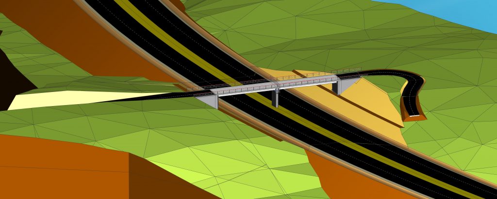
The CAD-modelled construction is always associative to the LandXML data set. Changes to the raw data therefore automatically lead to changes to the 3D volume body in Siemens NX. In this way, the LandXMLIntegrator guarantees you optimum process consistency between raw data, planning and implementation of constructions in the fields of civil engineering and traffic route construction. This enables you, for example, to optimally adapt the superstructure of a bridge construction to the space curve of the route whilst taking the surrounding terrain into account. As a result of the associativity between the superstructure and the space curve, all modifications automatically lead to changes to the superstructure and therefore to the entire bridge.
LandXML -The standardised tool for infrastructure projects
LandXML is the standardised format for measurement and planning data in the fields of civil engineering and traffic route construction. The information this contains is used by engineers from the construction industry to plan and implement road and infrastructure projects. The direct import from LandXML enables you not only to obtain an optimum visualisation of the digital terrain model, but also the structure of large-scale and complex
constructions in Siemens NX. After importing the 3D model, the reference lines of the route serve as your basis for the further modelling of an infrastructure construction directly in Siemens NX. This allows you to, for example, plan and model a bridge construction independent of the transverse and longitudinal tilts, as well as the course of the route in terms of location and height, whilst taking the surrounding terrain into account.
Contact
If you are interested in a company-specific custom development and would like to find out more, please feel free to get in touch with us.
Give us a call on: +49 (0) 86 54 / 77 88 56-0
or send an email to: info@neoapps.de
Alternatively, you can fill out our contact form here. We look forward to hearing from you.